|
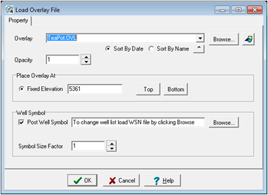
Overlay
|
Selects the overlay to display on the 3DViz module. By default, this tool looks in the project's Parms directory. To change the directory, select the Browse button and navigate to the desired location.
|
|

|
Opens the Overlay Layers and Preferences tool. Here, you can enable and disable different overlay layers. Note that the overlay file here is read only - though you can clear layers and change plotting order, these changes will not be saved back to the overlay file.
|
|
Opacity
|
Sets the opacity of the overlay file between 0 (transparent) and 1 (opaque).
|
|
Place Overlay At:
|
- Fixed Elevation - This option sets the depth (in SSTVD) to draw the overlay file.
- "Top" button sets this depth to the highest datum in the project, while the
- "Bottom" button sets this depth to the lowest TD in the project)
|
|
Well Symbol
|
Adds well symbols to the overlay file
|
|
Browse
|
Sets an additional filter for t
|
|
Symbol Size Factor
|
Sets the size of the symbols on the overlay
|
 button on the on the