Map Measuring Tools |
|
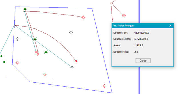
Petra provides two tools for quickly measuring the distance or area on a map: ·Measure distance tool ·Compute area inside a polygon Map Measure toolThe Measure Distance tool displays the distance and other information between two points on a user drawn line. To measure a linear distance:1.Start the measure distance tool:
2.Click anywhere on the map to set the start point. This will also change the cursor to a 3.Move the cursor to draw a line and click to set end point. Petra will display the distance, endpoint LatLon (or XY), the dx and dy in map units, and angle between the start and end points in the lower left module of the Map Module. ·To display the endpoint's XY location instead of LatLon points, select the "Measure Tool Shows XY instead of LatLon" option on the Map Margin and Preferences tool. ·To display distances in miles/kilometers rather than feet/meters, select the "Measure Tool Shows MILES or KM" option on the Map Margin and Preferences tool. Compute area inside a polygonThe compute area inside a polygon tool quickly calculates and displays the area of a polygon. To measure the area of a polygon:1.Start the compute area inside a polygon tool:
3.Click anywhere on the map to set the polygons start point. This the cursor will change to a 4.Draw a polygon by moving cursor and clicking to set polygon vertices When the polygon area has been selected Right-click the mouse to close the polygon. The area will be automatically calculated and displayed.
|

 .
.