Map Monthly Production Chart Options tab |
|
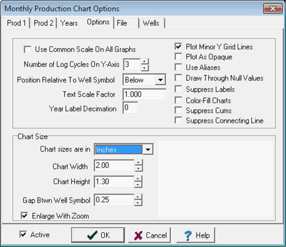
The Options tab sets some of the details and scaling for the monthly production charts. Use Common Scale On All Graphs - This option forces all 3 graphs to use the maximum computed scale. Number of Log Cycles on the Y-Axis - This entry sets the number of logarithmic decades. Position Relative to Well Symbol - This option sets the location of the monthly production plot around the well symbol. Text Scale Factor - This option resizes text. For example, setting this value to 1.5 changes the text to 150% of the default size. Year Label Decimation - This option decimates the year labels by the specified number. As an example, setting this option to "5" will only display every 5th year label. Plot Minor Y Grid Lines - This option draws the minor lines on the production axis. With this option deselected, only the logarithmic decade markers will appear on the plots. Plot As Opaque - This option plots the monthly production plots as opaque. Depending on draw order, this option may cover up other items on the map. Draw Through Null Values - This option will draw a line to connect all values. By default, months with no production have gaps in the graph line. Use Aliases - This option uses monthly production name aliases. Suppress Labels - This option removes labels on the Y axis. Color-Fill Charts - This option fills the area on the plots below the production curve. This can obscure other production data. Suppress Cums - This option prevents cumulative production values from appearing on the bottom of the production charts. Suppress Connecting Line - This option prevents a connecting line between the production plot and the well symbol.
Chart SizeChart sizes are in - This dropdown sets the size of the production plot in inches or XY map units. Chart Width - This entry sets the width of the production chart. Chart Height - This entry sets the height of the production chart. Gap Btwn Well Symbol - This option sets the space between the production chart and the well symbol.
Enlarge With Zoom - This option increases the size of the production plots when zoomed in on a smaller part of the map. |