Drainage Ellipses |
|
The Map Module can draw elliptical drainage ellipses around well symbols on the Map Module. These can help illustrate already drained areas and aid plans for future development. To add drainage ellipses, select Options>Drainage Radius from the menu bar at the top of the Map Module. Drainage Area tabThe Drainage Area tab defines the size of the drainage ellipse for each well.
Zone/Item - To add a drainage ellipse, select the zone and item that contains the overall area drained by the specific well. Unlike the ratio and orientation for the ellipse, the size requires a data item value for every well; wells with a null value for the drainage area will not have a drainage ellipse. Area Units - This drop down selects the units for the zone data item. This includes acres, square feet and meters, and hectares. Display As - This drop down selects the type of area units displayed on the map. Minimum/Maximum - These options set the minimum and maximum areas for the drainage radii. Wells with areas outside these limits either will not display on the map (when the "Ignore Data Outside Range" limit is selected), or just won't be any larger than the maximum or smaller than the minimum. Ignore Data Outside Range - This option disables any drainage radii that are outside the minimum and maximum set on the option immediately above. Colors - This tool can draw drainage radii in different colors based on their size. This button opens the Normal Color Interval Definition tool to set the desired color scheme. A/B Ratio tabThe A/B Ration tab sets the ratio of the ellipses' semi-major axis (A) to the semi-minor axis (B). The higher the ratio, the skinnier and longer the drainage ellipse.
Zone Item - Using a zone item allows the drainage ellipse to vary from well to well. Select the relevant zone and data item containing the ratio. Constant - This entry sets a constant ratio across all wells with an ellipse. Orientation tabThe Orientation tab sets the compass direction of the drainage ellipse. Petra reads azimuth as increasing clockwise from north at 0: N = 0, E = 90, S = 180, and W = 270.
Zone Item - Using a zone item allows the direction of the ellipse to vary from well to well. Select the relevant zone and data item containing the azimuth of the drainage ellipse. Constant - This entry sets a constant ratio across all wells with an ellipse. Options tabThe Options tab controls a couple of additional option on how Petra draws and labels drainage ellipses.
Color Filled Drainage - This option fills the drainage ellipse with the color (or colors) specified on the Drainage Area tab. By default, this color fill is opaque and will obscure elements below. To change this option to a transparent color fill, select "Plot as Transparent" on the General tab. Draw Color Scale Bar - When Petra uses multiple colors for the drainage ellipse, this option draws a scale bar on the map. Outline Drainage Area in Black - This option adds a black outline to the drainage area. This is a good option to select when the "Color Filled Drainage" option is de-selected. Multiply Each Z Value By - Multiplies the Z value by input value. Center Ellipse At Alternate Location of Fm Top - By default, Petra centers drainage ellipses on the well symbol. This option instead moves the drainage ellipse to the location of the formation top specified in the dropdown below. This can be useful for more accurately representing the location of drainage in deviated or directional wells. Wells tab
All Wells On Map - This option plots drainage ellipses on every well on the map. This option can create misleading maps, since it will include all wells on the map regardless of whether the produced out of the relevant formation or not. Wells From WSN List - This option limits drainage ellipses to only wells listed on a WSN list. This option is good for limiting drainage ellipses to only wells producing out of the relevant horizon, but will need to be updated as new wells are drilled. General tab
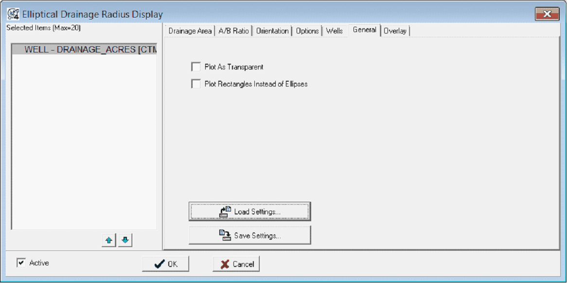
Plot as Transparent - Petra normally plots drainage ellipses with an opaque color fill (when the "Color FIlled Drainage" option is selected on the Options tab). This option plots color filled drainage ellipses with a transparent color fill. This can be useful when the drainage ellipses cover other map elements. Plot Rectangle Instead of Ellipses - This option posts a rectangle rather than an ellipse.
Load Settings - This button saves the drainage ellipse settings to an external *.DAM file. Save Settings - This button replaces the current drainage ellipse settings with those from an external *.DAM file. Overlay tab
Capture Ellipses to Map Overlay Layer - This option captures the drainage ellipses to the overlay selected on the dropdown below. R - This button renames the overlay layer selected on the dropdown menu. This can be useful for renaming a default layer name to something more descriptive. Clear - This option completely removes all lines, text, and images from the overlay layer selected on the dropdown menu. Include Polygon Labels - This option adds a volumetric polygon name (available on the Overlay Line Atribute's Volm tab) based on the well's WSN. Label Prefix - This option adds a prefix to the volumetric polygon name created by the "Include Polygon Labels" option. |