Images tab |
|
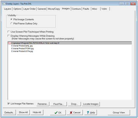
The Images tab controls how the Map Module displays image files on the overlay. This tab is most useful for reducing RAM/bandwidth-heavy visibility options and fixing broken links to external image files.
The Overlay Layers' Images tab VisibilityPlot Image Contents - This option plots images on the Map Module. Plot Frame Outline Only - Large aerial or satellite image files can use a large amount of computer resources and network bandwidth. This option plots a frame outline of the image extents rather than the image itself.
Use Screen Plot Technique When Printing - This tool changes how Petra sends images to the printer. Use this option if images are not appearing correctly in printed maps. Display Warning Messages While Drawing - This option enables or disables drawing warning messages. It's sometimes useful to disable these for frequent errors.
Image File Names ListIt's important to remember that Petra doesn't actually store any images in the overlay file. Instead, it simply keeps a link to the external file. List Image File Names - This option displays the list of linked image files and their paths. Rename - This option changes the name and pathway of the selected file. This is useful for keeping the same settings (such as GeoTIFF locations) while replacing the name. This can also be useful for fixing bad or outdated pathways. Find File... - This option instead opens a window to navigate to the new location of the selected file. Note that Petra will retain the old settings for the image. Drop - This option drops the existing image file from the list. Petra will not retain the link to the image file, but will not delete any files off the network or local hard drive. Locate Images - This option uses the search criteria established by ImageSearch.TXT to permanently fix the links to the image file. Depending on the number of missing files and the specificity of the search criteria, this can take a very long time.
|