Map Projections |
|
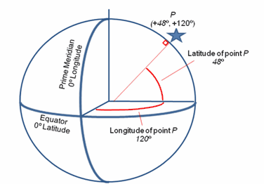
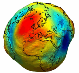
A map projection is an attempt to portray the curved surface of the earth on a flat piece of paper or computer screen. Put another way, map projections have two parts: the reference datum and the coordinate system. Reference DatumA reference datum (pl: reference datums) is a known and constant surface used to calculate latitude and longitude for a point on the Earths surface. A points longitude is simply the angle of degrees the point is away from the Prime Meridian. A points latitude, on the other hand, is the angle between the equatorial plane and a line that is normal to the reference datum. Its worth noting that since the earth is actually a little flattened, this line actually intersects the equatorial plane a little bit away from the very center of the Earth. Since different reference datums have different shapes, a single point can have different latitude and longitude depending on the reference datum used to make the measurement. Calculating latitude and longitude from a reference datum Imagine digging a series of narrow canals across the worlds continents. The height of the water inside these canals would be sea level at zero elevation. The global surface described by this zero elevation is called the geoid. The geoid is actually fairly bumpy due to unequal density distribution on Earth. The example below (from the European Space Agency) shows an exaggerated model of the Earths geoid, where red highlights a high geoid, and blue a low geoid. The closer the reference datum fits the geoid, the more accurate the map. Fitting a single reference datum to these bumps, however, has made the process of creating a single, accurate global datum difficult.
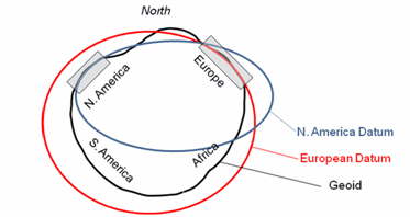
An exaggerated model of Earth's geoid (from the European Space Agency) Historically, the solution was to create a lot of different reference datums with different shapes and origins each of which is suited only for a specific region. The figure below shows a couple of different datums relative to the Earths geoid. Notice that the N. America datum in the example below closely models the geoid for North America, but is wildly off for the rest of the world. Likewise, the European Datum closely follows the geoid near Europe, but is greatly distorted relative to the geoid for the rest of the world. Note also that the N. American and European datums both have different shapes (known as ellipsoids) and origins.
A N. American and European reference datum relative to the actual geoid More recently, the trend has been towards creating more and more accurate global reference datums that are applicable to the entire globe. The WGS 1984 datum (used on GPS receivers) is a common global reference datum. Recall that a point's latitude and longitude are calculated from the reference datum. In order to correctly plot a specific latitude and longitude on a map, it's necessary to know the reference datum of that LatLon point. Practically, this means that not all LatLons are equivalent. A LatLon created with one reference datum won't be compatible with a LatLon based on another reference datum. Because of this, whenever you import any LatLon data (such as well spots or overlay data), its important that the reference datum of the project and new data are both known and accounted for. Coordinate SystemThe other part of the map projection is the coordinate system. The coordinate system essentially is a set of coordinates that transforms latitude and longitude on a globe into XYs on a flat map. The most common coordinate systems in North America are the state plane systems and UTM zones. In a sense, these two parts of a map projection (the reference datum and the coordinate system) constitute two separate steps. First, the reference datum is used to calculate LatLons for a location on a globe. Second, the coordinate system converts this LatLon data into XYs for plotting on a flat map.
How a location on a globe becomes an XY point on a map All coordinate systems, by virtue of trying to stretching a three dimensional globe onto a flat map, inherently introduce some distortion. This distortion can change the shapes of objects, distances between points, the azimuth between points, scales, or areas. All map projections are a tradeoff between different types of distortion. As such, there is no one universal best projection suitable for all areas. Even for a small area, the best projection is still arguable. An alternative way of selecting a coordinate system is to look for a useful coordinate system. Things to consider include the coordinate system any collaborators are using, the coordinate system used by legacy maps of the area, and what projection your existing data uses. |


