|
The Wells Symbol Style dialog sets how the well symbols are drawn and labeled. The well label is a single line of text and can be used as an alternative to using Data Posting.
Symbol tab

The Well Symbol Style's Symbol tab
Symbol Size
These settings control how the Map Module displays well symbols.
Small - This sets the well symbol size to 0.05 inches.
Medium - This sets the well symbols to 0.075 inches.
Large- This sets the well symbols to 0.12 inches.
Custom - This option sets the well symbols to a specified size. This size can be set in inches or XY units on the Options tab.
Enlarge with zoom - This option enlarges well symbols as you zoom in.
Limits - The Min and Max entries set the minimum and maximum size in inches for the well symbol. Setting this entry to "0" turns off the limit.
Symbol Location
This option sets the location of the well symbol. This also sets the default location of data points along deviated wells for some gridding applications.
Surface Location Only - This option displays the well symbol only at the surface location.
Bottom Hole Location Only - This option displays the well symbol only at the bottom hole location.
Surface & B-Hole w/ Symbol at B-Hole - This option plots the well symbol at the surface location with the "BH Marker" at the bottom hole location
Surface & B-Hole w/ Symbol at Surface - This option plots the well symbol at the bottom hole location with the "Surface Marker" at the surface hole location
Symbol Color
Use Default Color Only - This option draws all well symbols using the "well symbol default color" defined in the System Color and Style Definitions tool.
Use Symbol Definitions - This option draws well symbols using each wells' symbol definition specified on the Main Module. These defaults can be modified with the Well Symbol Descriptions section.
Annotation tab
This tab sets up simple well labeling around all wells. It only appears when the "Allow Simple Well Labeling" option is selected on the Options tab.
This annotation system is independent from the more elaborate and comprehensive data posting system.
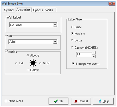
The Well Symbol Style Annotation tab
Well Label - This option sets the label that will appear around each well. Options include:
No Label (Suppress the well label)
Unique Well Id (UWI or API Number)
API Series No. (5-digit series number or the UWI)
Well Short Name
Well Label
Well Seq No. (WSN)
Font - This option sets the desired font for the label.
Position - This option sets the position of the label to above, below, left or right of the well symbol.
Label Size - This option sets the size of the label. Options include:
Small - This sets the text size to 0.05 inches.
Medium - This sets the text size to 0.075 inches.
Large - This sets the text size to 0.12 inches.
Enlarge with zoom - This option enlarges the annotation text as you zoom in.
Options tab
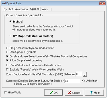
The Well Symbol Style's Options tab
Custom Sizes Are Specified As
Inches - This option sets the symbol custom size in inches.
XY Map Units - This option sets the symbol custom size in XY map units.
Flag "Unknown" Symbol Codes with X - This option will draw an X on all of the open circle well symbols that do not have a description defined for the symbol code. By default, Petra draws an open circle for these wells, which is identical to the "LOC" symbol.
Use Opaque Symbols - This option causes open wells symbols, such as a gas or dry hole symbols, to be plotted using the background color (normally white) to fill the interior of the symbol. Use this option when you wish the well symbols to stand out against a colored background.
Disable Mouse Selection of Wells That Are Not Initial Completions - This option prevents recompletions from being selected on the Map Module. With this option turned on you will not be able to select a well if the UWI does not have 14 characters or it does not end in 00.
Allow Simple Well Labeling - This option allows simple
Plot Wells Even if Location is Outside Limits -
Exclude "Pseudo" Wells When Loading Wells -
Zoom Factor When Hilite Well from Main (0-200) -
Surpress Detailed Deviation Surveys for Scales >... -
Wells tab
The Wells tab establishes "Primary" and "Secondary" wells. Secondary wells are grayed out and can be plotted at half scale. This can be useful for distinguishing between the relevant wells in a project and wells that are too shallow or otherwise lack useful information.

Wells tab
Spot All Wells With Normal Size and Color - This option plots all wells normally.
Spot Primary Wells In Normal Mode with Secondary Wells Plotted 1/2 Size and Grayed Out - This option plots wells NOT in the WSN list at the bottom of the screen at half size and grayed out.
Spot Primary Wells in Normal Mode with Secondary Wells Plotted Full Size and Grayed Out - This option plots wells NOT in the WSN list at the bottom of the screen at full size and grayed out.
|