|
Click Here for a "How-To" guide on creating Contour Grids
The Limits tab sets the extents and edges of a calculated grid.
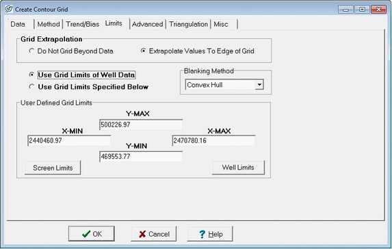
The Create Contour Grid Limits tab
Grid Extrapolation
By default, the gridded surface extends only over the area of the map containing wells. Alternatively, you may have the grid values computed over the entire range of the grid limits. Extrapolating beyond the data control points can sometimes result in unreliable or runaway grid values. Also, see "Extrapolation Distance" in the Advanced section to control the amount of extrapolation produced.
Do not Grid beyond Data This option limits gridding only to the data points in the Map Module.
Extrapolate values to Edge of Grid This option extrapolates the slope of the grid beyond the selected data points.
Grid Limits
The grid limits govern the extents of a grid. For aesthetics or to save gridding time, its often useful to limit gridding to only the relevant area.
Use Grid Limits of Well Data This option extends gridding out to all selected wells in the Map Module with data.
Use Grid Limits Specified Below- This option limits data to the X and Y limits defined in the User Defined Grid Limits box below.
User Defined Grid Limits This field has 4 boxes outlining the maximum and minimum X (East-West) and Y (North-South) values. You can enter your own grid area XY limits. Selecting the Screen Limits button automatically populates these boxes with the current view on the map, while the Well Limits button populates these boxes with the extents of all selected wells.
Blanking Method
The blanking method determines how Petra handles the edges of rectangular grids when the Do Not Grid Beyond Data option is selected on the Limits tab. Since triangular grids only interpolate directly between data points, blanking methods have no effect on these types of grids.
Neighbor Search This method draws color fills and contours out to the edges of the grid, which most often will be the extrapolation distance. This can result in a jagged grid edge around corner wells on rectangular grids.
Convex Hull - This method trims grids beyond a polygon defined by the outer-most data points. This results in smoother edges.
|