|
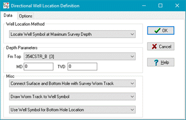
Well Location Method
|
-
Locate Well Symbol at Maximum Survey Depth - Well symbols are spotted at the position of the deepest survey depth.
-
Locate Well Symbol at Formation Top Depth - Wells are located at a depth defined by a formation top.
-
Locate Well Symbol at Measured Depth - Wells are located at a specified measured depth value.
-
Locate Well Symbol at True Vertical Depth - Wells are located at a specified TVD value.
-
Locate Well Symbol at Actual Bottom Depth - Wells are located at a specified BD value.
|
|
Depth Parameters
|
Specifies the location depth selected in the Well Location Method.
|
|
Misc
|
-
The surface location can be connected to the bottom-hole location by either a straight line of by drawing the actual survey "worm" track.
-
When the worm track is drawn, it can extend all the way to the maximum depth location or stop at the well symbol.
-
When the Formation Top Depth Well Location Method is used, you may select to spot the well symbol associated with the formation top instead of the normal well symbol.
|