|
Make sure to have a backup of the entire project before attempting this.
Since this process changes the reference datum on which all LatLon data relies, Petra will recalculate the LatLons based on the new reference datum. Since the LatLon data changes, Petra will apply a new coordinate system to calculate new XY points. The example will show changing a project from Oklahoma North (NAD27) to Oklahoma North (NAD83). While both these coordinate systems are named the same (Oklahoma North), they are based on two separate datums so they calculate XYs differently.

Practically, changing a project's reference datum is done in two parts:
- recalculate the LatLon and XY of every well location
- recalculate the LatLon and XY of all auxiliary files including overlays, grids, XYZ files, and LatLonZ files.
Reprojecting Well Data and Overlays
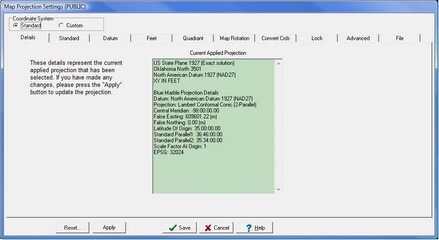
- Open the Map Projection Settings box Main: Project > Settings > Set Map projection.... In the example below, the project has a Standard Oklahoma North (NAD27) projection.
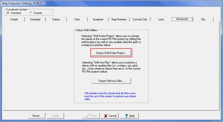
- Select the Advanced tab, and click,Datum Shift Entire Project.
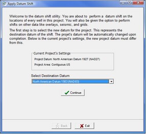
- Select a new project reference datum from the drop down menu and click Continue to set the new datum.
.
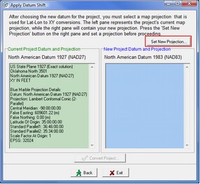
After selecting the new datum, Petra compares the current map projection on the right to the new projection on the left. Notice that the window on the right is empty, as no coordinate system is set.
- Click Set New Projection
.
This opens up the coordinate system window. This screen has two major lists: the Coordinate System Types, and the individual Coordinate System Names. The Coordinate System Type list (highlighted in blue) shows all coordinate systems available for the currently selected reference datum. In the example below, this list only shows coordinate systems that use the NAD83 reference datum. Here, select the type of coordinate system for the project. In the example below, US State Plane 1983 is selected.
Selecting the coordinate system type populates the Coordinate System Name list with specific coordinate systems (highlighted in green). In the example below, the Oklahoma North state plane coordinate system is selected.
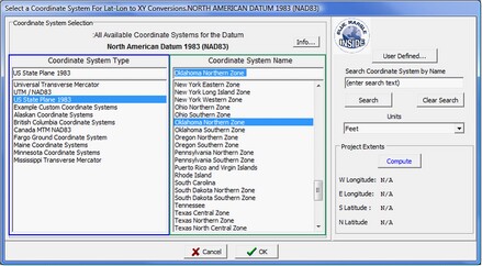
Selecting a standard coordinate system
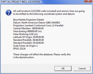
This brings up the comparison window again. This time, the window to the right is filled in with both the current and new map projections. Select Convert Project to continue (highlighted in red). Petra opens one final screen to confirm the changes. Select OK.
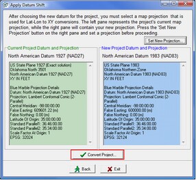 
A comparison between the old and new projections (Left), confirming the datum shift (Right)
Reprojecting Overlay files, Grids, LatLonZ, and XYZ files
After converting the well locations, Petra automatically prompts you to apply the same datum shift to overlay files, grids, XYZ files, and LatLonZ files. Since the well locations have changed, its important to reproject the other data to match. Though the example below has all auxiliary data checked, you only need to select data appropriate for your project.
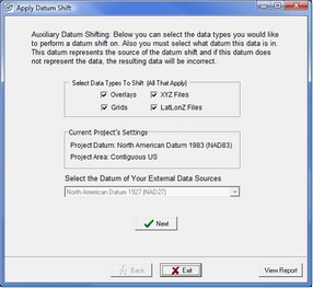
Applying the datum shift to overlays, grids, XYZ files, and LatLonZ files
Reprojecting Overlay Layers
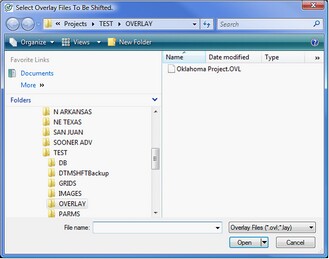
The next step is to select which overlay layers to reproject into the new map projection. Clicking Select Files opens up the projects OVERLAY folder in an external Microsoft Explorer window. Drag and drop files from the Explorer window into the Input Overlay Files window (highlighted in red). Petra also automatically creates a backup of all overlay files when a datum shift is applied. The backup filename simply appends a timestamp (YYYYMMDD_HHMMSS) between the overlay name and file extension. You can also add a prefix to the backup file name. In the example below, the prefix of BACKUP is added. Select Convert Overlay(s) to reproject the selected overlay files.
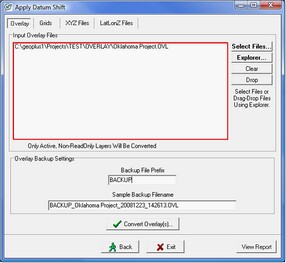 
Selecting the overlay to reproject (Left), setting the location of the reprojected overlay (Right)
Reprojecting Grids
Next, select the Grids tab. The Grids tab shows a list of the grids to be reprojected. By default, Petra looks in the projects GRIDS directory. Its worth noting that the datum shift tool can only reproject one folder of grids. If your project has multiple grid folders, you can either move them all into one folder or perform the Datum Shift Aux Files function for each folder.
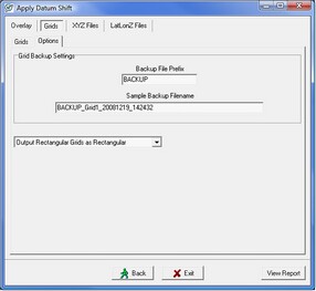
The Options tab for the Grid tab controls a few more options about datum shifting grids. Petra automatically creates a backup of all grid files when a datum shift is applied. The backup filename simply appends a timestamp (YYYYMMDD_HHMMSS) between the grid name and file extension. Its also possible to add a prefix to the backup file name. In the example below, the prefix of BACKUP has been added. This tab also controls how Petra resamples the existing grids to fit the new projection. The grids can be output as rectangular or triangular grids.
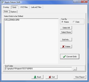 
Selecting a grid to reproject (Left), setting the location of the reprojected grid (Right)
Reprojecting XYZ Files
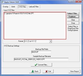
External XYZ control points need to be reprojected in order to plot correctly on the map. Under the XYZ Files tab, select which XYZ files to reproject into the new map projection. Clicking Select Files opens up the projects root directory folder in an external Microsoft Explorer window. Drag and drop files from the Explorer window into the Input XYZ Files window (highlighted in red). Petra also automatically creates a backup of all XYZ files when a datum shift is applied. The backup filename simply appends a timestamp (YYYYMMDD_HHMMSS) between the XYZ file name and file extension. You can also add a prefix to the backup file name. In the example below, the prefix of BACKUP is added. Select Convert Files
to reproject the selected XYZ files.
Selecting the XYZ file to reproject (Left), setting the location of the reprojected XYZ file (Right)
Reprojecting LatLonZ Files
External LatLonZ control points need to be reprojected in order to plot correctly on the map. Under the LatLonZ Files tab, select which LatLonZ files to reproject into the new map projection. Clicking Select Files opens up the projects root directory folder in an external Microsoft Explorer window. Drag and drop files from the Explorer window into the Input LatLonZ Files window (highlighted in red). Petra also automatically creates a backup of all LatLonZ files when a datum shift is applied. The backup filename simply appends a timestamp (YYYYMMDD_HHMMSS) between the LatLonZ file name and file extension. You can also add a prefix to the backup file name. In the example below, the prefix of BACKUP is added. Select Convert Files
to reproject the selected LatLonZ files.
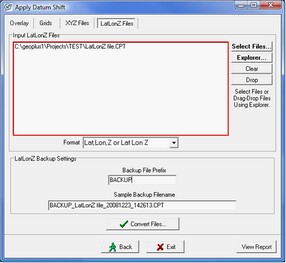 
Selecting the LatLonZ file to reproject (Left), setting the location of the reprojected LatLonZ file (Right)
*This example essentially changes the map projection from the NAD 27 Oklahoma North state plane to the NAD 83 Oklahoma North state plane. While both these coordinate systems are named the same (Oklahoma North) and they share the same north and southern latitudes, they are based on two separate ellipsoids so they calculate XYs differently.
|