Z Cross Plot Polygons


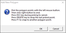
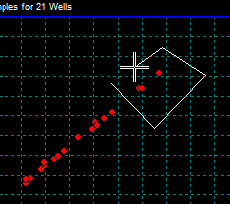
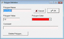
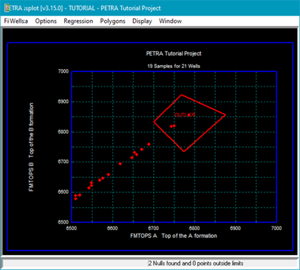
Z Crossplot polygons outline different areas of the graph, separating wells that have specific z data relationships.  Each polygon in the Z Crossplot Module can have its own name, color, and value.  

Polygon values don't have any effect in the Z Crossplot Module, but exist so that polygons can be shared with the Log Crossplot Module.  Polygons allow the user to select wells based on a custom criteria rather than by simple data searches.  

Add a Polygon

To add a polygon:
  1. Open the "Add New Polygon"dialog:

  • From the modules menu Z-Crossplot: Polygons > Add

  • Right click anywhere on the log plot and select Add Polygon. This dialog describes the key strokes used in drawing a polygon.

  1. Draw a polygon by picking points with the left mouse button. Close the polygon by clicking the right mouse button.

  1. Once the polygon is drawn, Petra opens the Polygon definition dialog allowing you to name and define the polygon.

  1. Save the Polygon Z-Crossplot: Polygons > Save....

    On the "Save Polygons to Disk" dialog, the area outside the polygons name and value can be modified.  By default this area is named DEFAULT and its value is zero.  This screen also allows for a comment to better describe the polygons.

Closing the Log Crossplot Module erases the polygons from Petra's memory, so make sure to save the polygons to a file if you want to use them later.

Additional polygon actions

From the polygon menu or context menu (Right click) you can do the following:

Show

Toggles displaying active polygons on/off

Add

Create additional new polygons

Select

Selects a polygon by clicking cursor on any line of a polygon

Modify

Opens the "Polygon Definition" dialog to modify a selected polygon. You must select a polygon first using the Select option.

Clear

Deletes all polygons from memory. Saved polygons are still available for future use.

Load

Loads saved polygons

Save

Opens the "Save Polygon" dialog. You must select a polygon first using the Select option.

Export

Saves a WSN list of all the wells within a polygon

Highlight Wells on map

Highlights wells within polygon on the map.