Using the Ruler and Planimeter Polygon
The ruler and planimeter polygon provide you tools to measure either distance or area on the Spatial Explorer map. Both tools are available on the map view toolbar by clicking ![]() . By default, the measuring tool is set to the ruler and the units are set to metric, and you can change the measurement to the planimeter polygon and the units to English / Field needed.
. By default, the measuring tool is set to the ruler and the units are set to metric, and you can change the measurement to the planimeter polygon and the units to English / Field needed.
- From the toolbar, click
 .
. - Select the measurement type (ruler or planimeter polygon) and unit of measure (English or Metric).
- Click Digitize.
- To initialize the ruler or polygon, click the point where you want to measure distance or area. You can create as many points as needed. Press and hold the Control key (Ctrl) if you want to disable the cursor snapping to any polygons or wells you are measuring (the layer you are measuring must be the active layer for snapping to work).
- Double-click to complete the ruler or polygon. The measurement results display in the Ruler| Planimeter Polygon window.
- Click Digitize or Clear to remove any line segments and start over.
- Click Close to close the Ruler/Planimiter Polygon window.
For planimeter polygons:
- If you want to save the digitized polygon in Kingdom, click Save To Kingdom . The polygon is saved with the name Arean where n is a generated sequential number.
- (Kingdom and Harmony) If you want to save the digitized polygon as an editable layer in Spatial Explorer, click Save to Editable Layer, type the name of the layer, and then click OK.
The Ruler/Planimeter Polygon window
The table below explains the purpose and use of the various fields on the Ruler|Planimeter Polygon window.
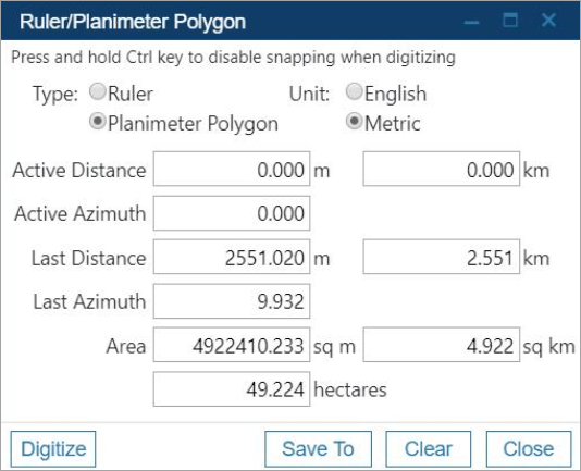
| Field | Explanation |
|---|---|
|
Type |
Ruler for measuring distance, or planimeter polygon for measuring area. |
|
Unit |
English / Field (feet, miles, and acres) or Metric (meters, kilometers, and hectares) |
|
Active Distance |
The length of the line segment you are currently drawing on the map. This resets to 0 when you click to end a segment or double-click to complete the entire line or polygon. |
|
Active Azimuth |
The direction of the active line segment. |
|
Last Distance |
The length of the previously drawn line or polygon segment. |
|
Last Azimuth |
The direction of the previously drawn line or polygon segment. |
|
Total Distance (ruler only) |
The total distance of all line segments. |
|
Area (polygon only) |
The total area encompassed by the polygon. |
|
Acres/Hectares |
Total area of the planimeter polygon converted to acres or hectares. |