Data Posting Data tab |
|
The Data Posting Data tab controls how data is posted around the well symbols on the Map Module. To open the Data Posting tool, select the
Available Data ItemsTo add an item to the data posting, select the desired well header, zone data item, or pd cum value on the Available Data Items List and select the Well Header Items - This dropdown selects well header info to add to the data posting box. This is most commonly used to add well identifier information, such as well name and number. Zone Data Items - These two dropdowns select the zone and data item to add to the data posting. The upper dropdown selects the specific zone, while the lower dropdown selects the data item in the selected zone. Note that Petra treats formation tops as a zone - to add a formation top, select the "FMTOPS" zone on the upper dropdown and the desired top on the lower dropdown. The Pd Cum Items - This dropdown adds cumulative production data, visible on the Main Module'sProd Cum tab. This includes formation names, tops/base, and cumulative values. Selected Data ItemsThis list box displays all the well data items displayed on the Map Module.
Data Posting tabsStyle tabEach posted data item contains posting attributes including the position relative to the well symbol, text color and size, number of numeric decimal places and how the value is labeled. Additional attributes can be set for formation tops including whether to use alias names and whether to post subsea values. All Z values can have the "quality" code and "units" posted following the value.
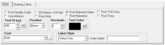
Post Quality Code - Check this option to have the quality code posted following a zone data or top item. Null values will show only the quality code. SS Datum = 0 If Null - This option is used in conjunction with the subsea tops option and causes posted subsea tops to be computed using a datum value of zero if the datum is null. Otherwise, the subsea top value will post as a null value when the datum is null. Post Subsea Top - Use the option when posting formation tops and you want to see subsea values. Subsea values are computed as: SS=Datum-Top. Post Times - This option appends the seismic time (ms) to the posted depth value. Times are calculated using the active velocity function for each well (from the "other" tab in main). Suppress Source - This option suppresses the display of the source portion of the item name when the Label Style includes the name. Use Aliases - If you have defined aliases, use this option to have the aliases searched for when posting a value. Post Units - This option causes the units value to be posted following the zone or top value. Post Remarks - This option causes the remark field associated with the top or zone value to be posted. Text Height - This section sets the text height for the selected data item. Text heights or sizes are specified in either inches or map XY units, e.g., feet, depending on the size option located on the Options tab. When using XY map units, text will vary in height depending on the map scale. When specified in inches, text is also the specified height, regardless of the map scale. Inch text heights will enlarge slightly when you zoom in if the "Enlarge With Zoom" option is selected. Click the ALL button to set all text to the same height. Position - Text items can be posted in four positions around the well spot. Select the position to place the text item Above, Below, Left or Right of the well symbol on the map. Decimals - Set the number of decimal places to the right of the decimal point for numeric values. Whole numbers will still post as integer numbers. Only values with fractional parts will show the number of specified decimals. Text Color - Each text line item can be plotted in a different color. Choose from the palette provided by clicking on the color cell. Click the ALL button to set all text to the same color. HiLite By Quality - This section allows you to highlight individual lines of text based on the quality code associated with the zone or tops data value. You may specify one or more text strings, separated by a semicolon (;), that will be search for in the quality code field. When the quality code is found, the line that one well will be highlighted using the selected color as the text background color. Font - Each line item can have a font specified from the font list. Label Style - Several labeling styles are provided and control whether variable names are posted along with the value. Scaling tabThis option scales a displayed data item. This can be useful for displaying production in 1000s of barrels or changing imperial to metric units. Note that this option does not change the data in the database - it only changes the value for display.
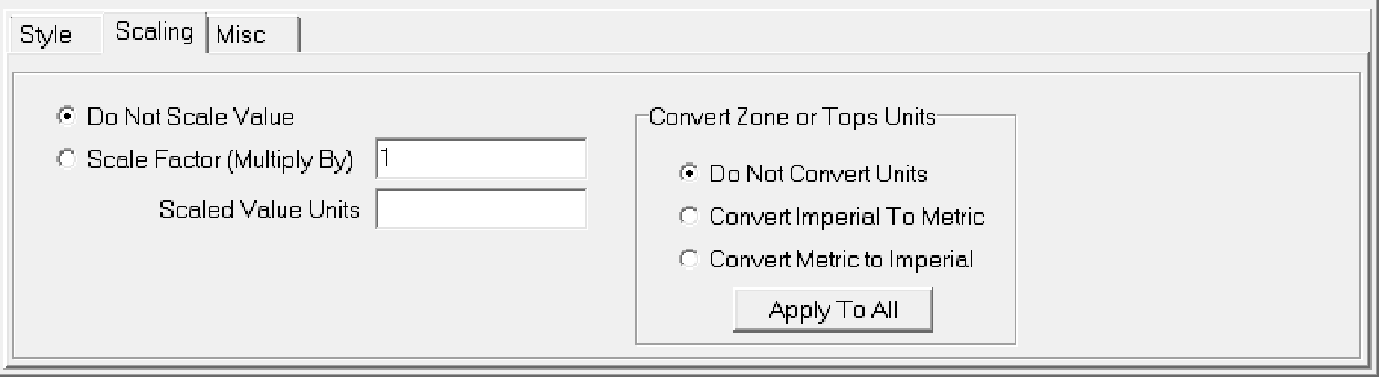
Do Not Scale Value - This option leaves the values displayed as is. This option is on by default. Scale Factor (Multiply By) - This option multiplies the selected data item by a constant. Multiplying a constant less than 1 will divide the data item. Scaled Value Units - This changes the value units displayed on the map module. Convert Zone or Tops Units - This section converts imperial and metric units. The "Apply To All" will convert all displayed zones and tops to use the selected unit. Misc tab
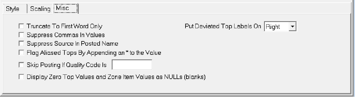
Truncate to First Word Only - This option only posts the first word in the data item. Suppress Commas in Values - By default, Petra puts commas at every third decimal point. This option removes commas in the values. Note that this option will not affect text items. Suppress Source In Posted Name - The "Zone: Item - Value" and "Item Name - Value" options post the source code for posted formation tops. This option removes the source in the posted name. Flag Aliased Tops By Appending an * to the Value - This option distinguishes between actual top and aliased tops. Petra will add an "*" at the end of the formation top value. Skip Posting if Quality Code Is - This option prevents the selected label's plot when the data item's quality code matches one of the quality codes inside the entry box. Separate multiple quality codes with a semi-colon. Display Zero Top Values and Zone Item Values as NULLS (blanks) - This option posts tops or zone data items with zero values as a blank. This option only affects the item highlighted on the Selected Data Items list. Note that this tool only affects the display on the Map Module, and does not change the values inside the database. |
 button on the toolbar at the top of of the Map Module, or select
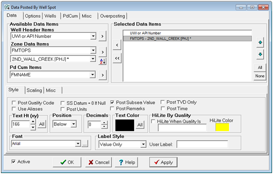
 button immediately to the right. Note that there are three buttons - the upper button adds the item selected on the "Well Header Items" dropdown, for example.
 button resorts the items on the lower data item dropdown into alphabetical order - this can be helpful for large numbers of tops.