Select Wells with Raster Log Images |
Raster Logs tab
Search Method Find Wells With Selected Rasters - This option returns wells that have the raster group names selected on the Choose Logs for Well Selection" list . Note that the "Raster Selection Mode" section further controls how the search handles multiple group names. Find Wells with ANY Rasters - This option returns wells with at least one raster log group. Find Wells With NO Rasters - This option returns wells with at no raster log groups. Find Wells with MJ Associated Rasters - This option returns wells that have the MJ Associated group names selected on the Choose Logs for Well Selection" list . Note that the "Raster Selection Mode" section further controls how the search handles multiple group names. Find Wells with IHS (Direct Connect) Rasters - This option returns wells that have the IHS Direct Connect group names selected on the Choose Logs for Well Selection" list . Note that the "Raster Selection Mode" section further controls how the search handles multiple group names. Raster Selection ModeSelect Well if ALL of the Selected Logs Are Present - This option returns only wells with ALL the digital curves selected on the "Choose Logs for Well Selection" list. Select Well if ANY of the Selected Logs Are Present - This option returns wells with at least one of the digital curves selected on the "Choose Logs for Well Selection" list . Select Well if NONE of the Selected Logs Are Present - This option returns wells that do not have any of the digital curves selected on the "Choose Logs for Well Selection" list.
Options tab
Use Aliases - This option uses the list of "equivalent" raster group names or aliases established on the Raster Log Maintenance's Aliases tab. Search For Uncalibrated Rasters Only - This option ignores raster logs with depth calibration points, and only selects wells with uncalibrated raster groups. This can be useful for troubleshooting a project, or for finding wells that need more work. Select When Source Contains - This option limits the search only to raster group names with a source code. This tool can use multiple quality codes - just separate the different codes with semicolons (;). When working with multiple conditions and a quality code search, the ALL or ANY selection mode set on the Raster Logs tab controls how Petra returns wells. With an ALL search, all of the group names need to have one of the quality codes. With an ANY search, only one of the group names needs one of the quality codes.
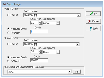
Depths tab The Depths tab sets up a depth range for the log curve search. With this option enabled, Petra will only return wells with at least a single raster calibrated depth inside this depth range. Note that the selection mode (any curve or ALL/ANY/NONE selected wells) will affect how the depth range works. As an example, the "Select Well if ALL of the Selected Logs Are Present" option, on the other hand, will only return wells with all of that have all of the groups on the well selection list inside the depth range.
Restrict By Logs Within a Depth Range - This option enables and disables the depth range search. Set Depths - This button opens the "Set Depth Range" tool. Note that the desired interval can be set to a formation top, MD, or TVD. For MD and TVD, select the relevant button and enter the adjacent depth in the entry field. For tops, select the desired top from the Fm Top Name dropdown box. Notice that an offset can also be added or subtracted to the fm top; this offset will include data points above or below the actual fm top depth.
|