Grid Volumetrics

Map: Contours > Volumetrics > Compute Volume From a Grid…

The Map Module's Compute Volume from a Grid tool calculates volumetrics from a single grid.  With a good quality isopach, pore volume, or hydrocarbon pore volume grid, this method can generate accurate estimations of the area occupied by hydrocarbons, and can divide these volumetrics into different lease polygons.

Data tab

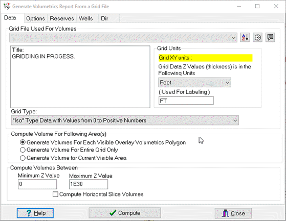
Grid File Used For Volumes

Selects the grid and grid type to be used in the calculation.

—Sorts list alphabetically

—Sorts list by most recently created

Grid Units

Selects units used to create grids.

By default, Petra assumes that the Z units for the grid are the Default Depths Units selected on the Map Projection Settings.  Make sure the units selected here reflect the units of the grid.

Grid Type

Selects grid type:

  • ISO type data with values from zero to positive numbers

  • Structure data with structural highs as larger numbers

  • Structural data with structural highs as smaller numbers

Compute Volume for Following Area(s)

Selects the volume underneath a grid will be broken out by different volumetric polygons.  

  • Generate Volumes for Each Visible Overlay Volumetric Polygon—Calculates the volume of the grid covered by every visible overlay polygon.

  • Generate Volume For Entire Grid Only—Ignores visible polygons and calculates the volume over the entire grid.

  • Generate Volume for Current Visible Area—Computes volume for a digitized boundary or current zoom limits.

Compute Volumes Between

Sets minimum and maximum Z value set limits on the overall volumetri calculation

Horizontal Slice Volumes

Calculates volumetrics for horizontal slices from the minimum z value to the maximum z value.

With large grids and small increments, this additional step can be fairly time-consuming.

Options tab

Provides additional options for the volumetrics calculation.

Ignore Volume if Thickness is Less Than

Sets minimum thickness to consider in the volumetric calculation

Grid Refinement

Breaks larger grid cells into smaller triangular areas.

This slightly increases the accuracy of the volumetrics calculation resulting in more computing time

Also Output Volumes to CSV File

Creates a CSV file using the volumetric grid name in the project GRIDS directory

Print Average Value for each Polygon in Report

Calculates the average grid thickness for each visible named polygon

Apply Working Interests Associated with Overlay Polygons

Scales each volume inside a volumetrics polygon by the working interest

Write Volumes to SHAPE FILE

Saves currently visible volumetric polygons and data to a shape file

Reserves tab

The Reserves tab selects the type of reserves calculation and specifies the type of input grid.

Types of Reserves Computed
  • Basic Volumes (No Scaling)—Calculates the volume occupied by the grid without any additional reservoir calculations

  • Oil in Place with Recovery—Multiplies the total area of pore space occupied by hydrocarbons by a recovery factor.

  • Gas in Place with Recovery— Multiplies the total area of pore space occupied by hydrocarbons by a recovery factor.  This volume is then divided by Bg to correct for differences in volume between hydrocarbons in the reservoir and the same hydrocarbon at surface conditions.

  • (CBM) Gas in Place with Recovery—Calculates reserves for a coal bed methane field.

    The map Type has no effect on these calculations, and the grid is always assumed to be an isopach grid.

  • Coal Tonnage —Calculates the volumetrics of an isopach grid and multiplies this value by an average coal density.

Show Results As

Selects units for Area and Volume

Wells tab

Petra can copy the volumetric data for each named polygon to a specific wells designated zone and data item. The Store Polygon Volume in Each Polygons Designated Well option stores the calculated volume to the designated well.

Store Polygon Volume in each Polygon's Designated Well

Stores the calculated volume to the designated well

Zone To Store Polygon Volume

” Selects the zone where volumetric data will be stored.  By default, volumetric data is saved in the WELL zone.

Item to Store Polygon Volume

Selects the specific data item where the relevant volume is stored.

Item to Store AVG Z Value in Polygon ...

Selects the specific pre-existing data item where the average grid thickness for each visible named polygon is stored

Dir tab

This tab simply sets the directory of available grids.  By default, this option is set to the projects GRIDS folder.

Related Topics