|
Once linked to the WMS server, Petra compares the projects EPSG code with the servers available datas EPSG codes and displays the WMS layers that are available. If multiple layers are requested, the WMS server stacks these layers into a single image and delvers it to Petra. One of the complications of multiple layers is that its often necessary to manually change the drawing order. As an example, reordering might be required to put vector data (like pipelines and roads) on top of non-vector data (like aerial and satellite photos).

To select and change layers order
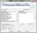
1.Access the WMS Imagery Settings dialog box:
·Menu navigation, Map Module: Display > WMS Imagery Settings
·Clicking the blue wrench icon  on the Map Module's Quick List Imagery panel. on the Map Module's Quick List Imagery panel.
2.Select the desired WMS server(s) from the Servers list.
3.Double click, or use the controls to move desired Layers from the Layers Available to the Layers Selected list box.
4.Select individual layer in the Selected Layers list box and use the UP or Down controls to arrange order of layers.
5.Click OK.
IMPORTANT: Layers on the top of the list are drawn before (and below) layers on the bottom of the list.
Related Topics
WMS imagery settings
|

 on the Map Module's