Spotting a Location From a Quarter Call (Kingdom only)
After you have created a quarter section on the Spatial Explorer map, you can use it to locate a new well. One method for spotting a well is to define the location using quarter calls. The underlying principle of this method is to specify a location based on a series of statements identifying location using the quadrants of the quarter section. Each statement in the series provides a further refinement of the well location from the four primary quadrants of the quarter section. In effect, each statement further subdivides the four quadrants of the quarter section into another four quadrants.
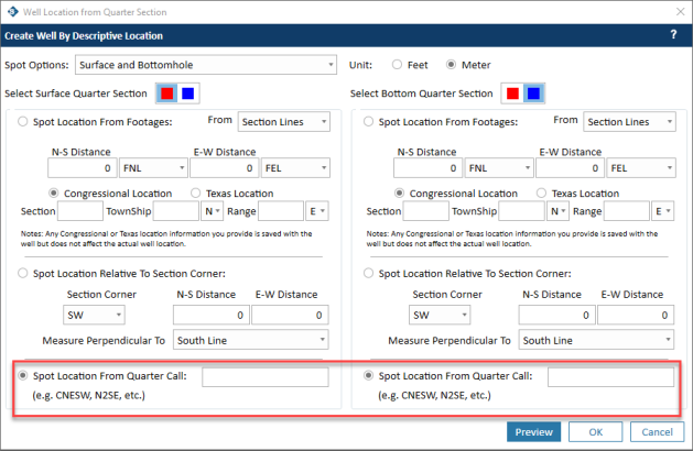
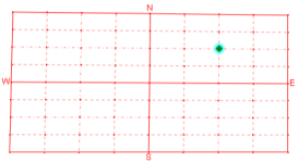
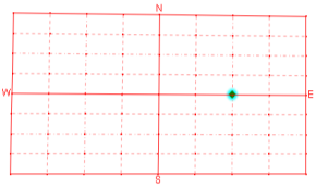
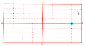
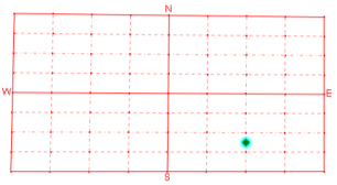
For example ,the quarter call NE places the well in the center of the northeast quadrant of the quarter section. The quarter call NENE places the well in the center of the northeast corner of the northeast quadrant, and the quarter call NENENE places the well in the center of the northeast corner of the northeast corner of the northeast quadrant. The table below shows the results of this progression of quarter calls.
|
Quarter call: NE |
|
|
Quarter call: NENE |
|
|
Quarter call: NENENE |
|
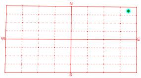
Quarter calls also support statements that place wells on the center of quadrant lines, not just in the center of quadrants. For example, the quarter call N2 places the well at the midpoint of the northern half of the north-south center line of the quarter section, and the quarter call E2 places the well at the midpoint of the eastern half of the east-west center line of the quarter section. And you can combine more than one call to refine your well location. For example, the quarter call E2E2 places the well on the east-west center line in the eastern half of the eastern half.
|
Quarter call: N2 |
|
|
Quarter call: E2 |
|
|
Quarter call: E2E2 |
|
You can combine the statement types as needed to accurately locate your well on the quarter section grid. For example, the quarter call N2SES2 places the well in the northern half of the southeast corner of the southern half of the quarter section. That places the well here:
After creating a quarter section or sections, follow the steps below to create a new well by spotting the location from a quarter call.
- Select
 from the Create Well toolbar. This opens the Create Well By Descriptive Location window.
 - From the Spot Options list, select whether to create a well by surface location only or by surface and bottomhole location.
- Select your unit of measure (feet or meters).
- If you are creating both a surface and a bottomhole location, accept the default colors or select the quarter section grid colors (red or blue) for the surface and bottomhole locations (this is only applicable if you created two quarter sections).
- Select the option Spot Location From Quarter Call.
- Type the quarter call statements you need to properly locate the well.
- If you are specifying a bottomhole location as well, repeat Step 6 for the bottomhole location. Keep in mind that if you created a second quarter section grid for the bottomhole, the location you spot is determined using this second quarter section.
- Click Preview to see where the well will be located.
- After you are satisfied with the well location, click OK. This opens the Create Well window.
- At a minimum, you must specify a UWI or accept the default UWI for the new well on the first Create Well window. Complete any other well information, then click Next.
- When you are done specifying well information, click Create Well.