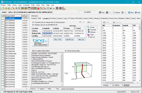
Location tab


The location tab on the main module displays and controls:

·Individual well locations

·Directional surveys

·Project-wide map projection

MainLocTab

_bm6

Undoes the last change to the well when displayed

Data grid

Displays selected well's latitude, longitudes, and XY coordinates in table format for:

·Surface location

·Bottom hole location

·Landing

Additional location parameters

Additional location parameters

· Directional survey data

· Congressional location information

· Offshore location information

· Texas location information

· Northeast location information

Opens wells location in bing maps

BHL_SHL_Button

Overwrites bottom hole location (BHL) with the surface hole location(SHL)

Calc Bottom Hole Location

For directional wells, uses survey data to calculate the bottom hole (BH) location

Lock

Locks currently selected well's location. Locked well locations cannot be changed either manually or by data imports.
Note: Project-wide location locking is enabled or disabled from the Program Options tool's Locks tab.

Directional survey table

Provides:

·Option to display values for MD and calculated TVD for X/Yoffsets or Inclination/Azimuth

·Insert/Append/Delete survey data directly from Excel using right-click context menu.

·Movable TVD column using drag and drop method. When TVD column is moved placement will persist until moved again.

Show Survey Data

Optional 3D view of directional survey