Directional survey data |
|
Petra uses directional survey data to compute the positions of deviated and horizontal wells for mapping, cross-sections, and calculations. Survey data from a directional drilling company usually consists of some combination of measured depth (MD), inclination (INC), azimuth (AZI) true vertical depth (TVD), North-South offset footage (NS) and East-West offset footage (EW). To access a wells survey data, select the Dir Survey button on the Location tab in the Main module.
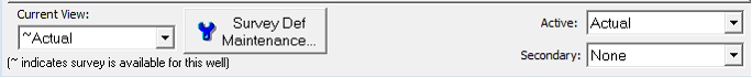
Data conventionsThe convention for inclination is 0 degrees for vertical and 90 degrees for flat. Inclinations above 90 degrees are inclined up. As an example, an 86 degree inclination is going down through section at 4 degrees below horizontal, and a 94 degree inclination is going up through TVD at 4 degrees above horizontal. Azimuth data is commonly measured in positive degrees measured clockwise from north, where 0 degrees is north, 90 is east, 180 is south, and 270 is west. This convention is sometimes called unformatted. Less commonly, azimuth data consists of a numeric compass heading in degrees preceded by either the letter N or S and followed by the letter E or W. As an example, N30E means 30 degrees east of north. S60W means 60 degrees west of south. This convention is sometimes called formatted. Petra can import and display azimuth data in either convention. The convention for NS offsets is north offsets are positive and south offsets are negative. Similarly, east offsets are positive, and west offsets are negative. Working with multiple directional surveysPetra can store any number of survey data sets (both real and planned) for any well. Multiple directional surveys are really intended only for proposed and actual surveys. Its best to keep each actual completion (even those from the same surface location) separate and in different wells in Petra. Keeping multiple drilled laterals in the same well greatly limits your ability to display in cross-section, map, and grid as well as store any useful header info or petro physical data. The multiple survey toolbar is available on the bottom of every tab on the Directional Survey Data window.
Survey Def Maintenance - This button opens the Survey Def Maintenance tool, which changes how Petra labels different sets of surveys.
|