|
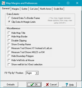
Miscellaneous
·Hide Map Title - Turns off the map title at the top of the screen.
·Hide Map Border - When the "Show Margin Frame On Screen" option is selected on the Margins tab, this option disables the Map Border (Data Limits + Margin) frame.
·Disable Clipping - Disables contour clipping polygons set on the Overlay Line Attributes tool.
·Show Overlay Name - Displays the name and location of the currently loaded overlay file in the lower left corner of the Map Module.
·Measure Tool Shows XY instead of LatLon - By default, the Map Module's Measure Tool displays the endpoint's location in latitude and longitude. This option instead displays the endpoint in XY units.
·Measure Tool Shows MILES or KM - By default, the Map Module's Measure Tool displays the distance between the start and endpoints in feet or meters. This option instead displays the distance in miles or kilometers.
·Hide Boundary Polygon - This option hides the outlines of boundary polygons on the Map Module.
·Hide Well Info at Mouse - By default, hovering the cursor over a well symbol displays the well's WSN and UWI in the lower left corner of the Map Module. This option disables the display.
·Show well list for Xsect Selection - This option displays the well list for the selected cross section.
|