|
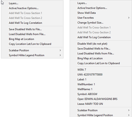
Layers
|
Opens the Overlay Layers tool
|
|
Active/Inactive Options...
|
Opens the Disable and Enable Map Options, which enables and disables different map elements.
|
|
Show Well Data
(selected well only)
|
Opens the selected well on the Main Module.
|
|
User Favorites
(selected well only)
|
Displays the user favorites dropdown display. The specific well header and zone data is set by the individual user.
|
|
Change Symbol Size...
(selected well only)
|
Changes the well symbol size of the selected well relative to the default well symbol size.
|
|
Add Well to Cross-Section 1
Add Well to Cross-Section 2
|
Adds the selected well to the end of the cross section in the Cross-Section Module.
|
|
Add Well to Log Correlation
|
Adds the selected well to the end of the cross section in the Log Correlation Module.
|
|
Disable Well (do not plot)
(selected well only)
|
Disables the selected well on the Map Module. Disabled wells do not plot, but are still honored during gridding. To re-enable wells, select Wells>Enable Wells Single Wells By WSN or Wells>Enable All wells that have been Disabled on the menu bar at the top of the Map Module.
|
|
Save Disabled Wells to File
|
Saves the disabled wells to a WSN list.
|
|
Load Disabled Wells from File
|
Disables the wells on a WSN list.
|
|
Bing Map at Location
|
Opens a Petra Map Browser window with a satellite map around the location at the cursor.
|
|
Copy Location Lat/Lon to Clipboard
|
Copies the cursor location's lattitude and longitude to the clipboard. This can be useful for copying into other software packages or for planning new wells.
|
|
Well Information
(selected well only)
|
Displays well header information at the bottom of the right mouse menu. This includes the WSN, UWI, well label, and other information.
|
|
Scale bar position
|
Moves scale bar position on map
|
|
Symbol Hilite Legend position
|
Moves symbol hilite legends position on map
|