|
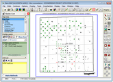
The Map module displays a map of the project area that can include wells, culture data, bubble maps, and attribute maps. The Map module also creates grids of geological surfaces or any other data that varies aerially.

To open the Map module:
Getting Started
Plotting Well Symbols
Adding Culture and Annotations with Overlay Data
Posting Data around Well Symbols
Creating Grids and Contour Maps
Adding Attribute Maps
Adding Bubble Maps
Adding Symbol Highlights
Adding Drainage Ellipses around Well Symbols
Displaying Log Curves under Well Symbols
Adding Production Charts around Well Symbols
Adding Dip Symbols
Posting IP/DST around Well Symbols
Addinng LatLon and XY Ticks to the Map
Adding WMS Aerial and Satellite Imagery
WMS Imagery
Working with Deviated Wells
Setting the directional well's symbol location
Displaying interval data on deviated well paths
Formation tops on deviated well paths
Adding dip-azimuth arrows on deviated well paths
Related Topics
Map Projections
Keyboard shortcuts
|
ESC Key
|
While redrawing the screen, terminates drawing and returns control to the mouse.
|
|
Space Bar
|
While redrawing the screen, terminates current map element and begins drawing the next element.
|
|
F1 Key
|
Snaps mouse cursor to nearest well.
|
|
F2 Key
|
Snaps mouse cursor to nearest overlay line control point with 0.1" tolerance.
|
|
F3 Key
|
Snaps mouse cursor to nearest quarter section grid intersection.
|
|
F4 Key
|
Hot key to activate moving posted data-by-well.
|
|
F5 Key
|
If an overlay line is selected, F5 shows the next overlay line sharing the common location.
|
|
F9 Key
|
Toggles between XY or Lat/Lon coordinates of the cursor location displayed in the status bar.
|
|
CTRL+F9
|
Toggles between approximate and true screen scaling mode.
|
|
"+" Key
|
While in zoomed mode, pressing the "+" key zooms in by 1/4 of the zoomed map extents.
|
|
"-" Key
|
While in zoomed mode, pressing the "-" key zooms out by 1/4 of the zoomed map extents.
|
|
Delete Key
|
Drop last well picked during cross-section well selection, deletes the currently selected overlay line or text item, drops last point while drawing an overlay line
|
|
Shift+Arrow Keys
|
Scroll the map while in zoom mode.
|
|
Alt+Arrow Keys
|
Move cursor one pixel on screen.
|
|
Control Key
|
Hold down the control key when doing a quarter section auto snap to find polygons containing more than 5 pts.
|
Mouse shortcuts
|
Left button
|
Single click WELL symbol
|
Selects well for moving, deleting, etc...
|
|
Double click WELL symbol
|
Jumps to the Main module and SHOW WELL DATA for the well
|
|
Single click on a well + CTRL
|
Selects next well plotted same location, such as multiple completions which post on top of each other
|
|
Double click Contour control point
|
Modify or delete it
|
|
Single click, hold and drag
|
Move a selected OVERLAY LINE control point
|
|
Single click + SHIFT+CTRL
|
Selects multiple overlay line or text items
|
|
Double-click + CTRL + ALT
|
Edit a posted GRID NODE VALUE
|
|
Click + hold down the CTRL
|
When SEISMIC LINE DIGITIZING skips to next shotpoint
|
|
SHIFT-Key held down
|
While moving posted well data other posted blocks of text move by the same xy
|
|
Right button
|
Single click on a WELL
|
Show a popup menu containing general well information
|
|
Single click + hold down SHIFT
|
Search for and display the nearest SEISMIC shot point number
|
|
Single click + hold down ALT
|
Move an OVERLAY LINE or TEXT item
|
|
Single click while moving posted well text
|
Reset the text to the default location.
|
|